class: center, middle # Introduction to GIS scripting ## Python for GIS INBO workshop, 9/11 May 2017 Stijn Van Hoey https://github.com/stijnvanhoey/course_gis_scripting --- class: center, middle # Recap --- class: left, middle * `Packages` provide new objects and methods ```python import datetime import numpy as np import pandas as pd ``` -- * `methods/functions` act on `objects` to do something -> `()` ```python np.sum(my_array) my_df.transpose() ``` -- * These objects have `characteristics/attributes` ```python my_array.size my_df.columns ``` -- * Some of these objects can be `sliced` -> `[]` ```python my_array[1:10:2] my_df["column_name"] ``` --- # Afternoon session * An introduction example * The GIS-ecosystem in Python * Vectors: the essentials * Raster suggestions * Desktop GIS interaction --- class: center, middle # Introduction showcase `03-geopandas-appetizer.ipynb` --- class: center, middle # Python's GIS ecosystem #### ## With a subjective flavour/selection --- class: center, middle, bgheader background-image: url(./img/StijnVH-ecosystem-gis-1.png) background-size: cover --- count: false class: center, middle, bgheader background-image: url(./img/StijnVH-ecosystem-gis-2.png) background-size: cover --- count: false class: center, middle, bgheader background-image: url(./img/StijnVH-ecosystem-gis-3.png) background-size: cover --- count: false class: center, middle, bgheader background-image: url(./img/StijnVH-ecosystem-gis-4.png) background-size: cover --- count: false class: center, middle, bgheader background-image: url(./img/StijnVH-ecosystem-gis-5.png) background-size: cover --- count: false class: center, middle, bgheader background-image: url(./img/StijnVH-ecosystem-gis-14.png) background-size: cover --- class: center, middle  [GDAL (Geospatial Data Abstraction Library)](http://www.gdal.org/) is the<br> open source Swiss Army knife<br> for raster and vector geospatial data formats. -- <br><br><br><br> <small>Traditionally `GDAL` used to design the raster part of the library, and `OGR` the vector part for Simple Features. Starting with GDAL 2.0, both sides have been more integrated.<small> --- GDAL's python bindings expose most of the functionality of GDAL. ```python from osgeo import gdal from osgeo import ogr ``` -- ### But... -- GDAL python bindings are not very "pythonic" ```python geo = gdal.Open(raster_file) drv = geo.GetDriver() print(drv.GetMetadataItem('DMD_LONGNAME')) ``` -- .center[  ] --- class: left, middle ### More pythonic libraries for reading GIS data * OGR (vector) -> Fiona * GDAL (raster) -> Rasterio --- ## fiona Fiona is a Python package for reading (and writing) `vector data`.<br> Fiona provides `Python objects` (e.g. a dictionary for each record) to geospatial data in various formats. ```python > with fiona.open('../data/deelbekkens/Deelbekken.shp') as deelbekkens: feature = next(iter(deelbekkens)) # Just one checking the first print("Bekken: ", feature['properties']['BEKNAAM']) print("Vectortype: ", feature['geometry']['type']) Bekken: Boven-Scheldebekken Vectortype: Polygon ``` --- ## shapely Shapely is a Python library for geometric operations (**GEOS** library). Shapely can perform: * geometry validation * geometry creation (e.g. collections) * **geometry operations** -- `difference`, `intersection`, `union`,... .center[  ] --- class: middle **Compare geometries** * `object.almost_equals(other[, decimal=6])` * `object.contains(other)` * `object.crosses(other)` * `object.disjoint(other)` * `object.equals(other)` * `object.intersects(other)` * `object.touches(other)` * `object.within(other)` --- ## pyproj ### handling Spatial Reference Systems (SRS) Examples: * `EPSG:4326` -> latitude, longitude in WGS-84 coordinate system * `EPSG:31370` -> Belge 1972 / Belgian Lambert 72 A number of formats exist to represent the SRS: * WKT * PROJ.4 * EPSG:xxxx --- class: center, middle # Vectors: the essentials `04-gis-python-vectors.ipynb` --- class: center, middle ## The curious case of GDAL --- ## GDAL functions: CMD Available on the command line... with [documentation](http://gdal.org/1.11/gdalwarp.html)...<br> .center[  ] <br><br> This [online cheat-sheet](https://github.com/dwtkns/gdal-cheat-sheet) is a great resource! --- ## GDAL functions: QGIS * Add [gdaltools plugin](https://docs.qgis.org/2.2/en/docs/user_manual/plugins/plugins_gdaltools.html) to QGis .center[  ] --- ## GDAL functions: QGIS * Build the command using the interface and copy paste your command for later usage... .center[ 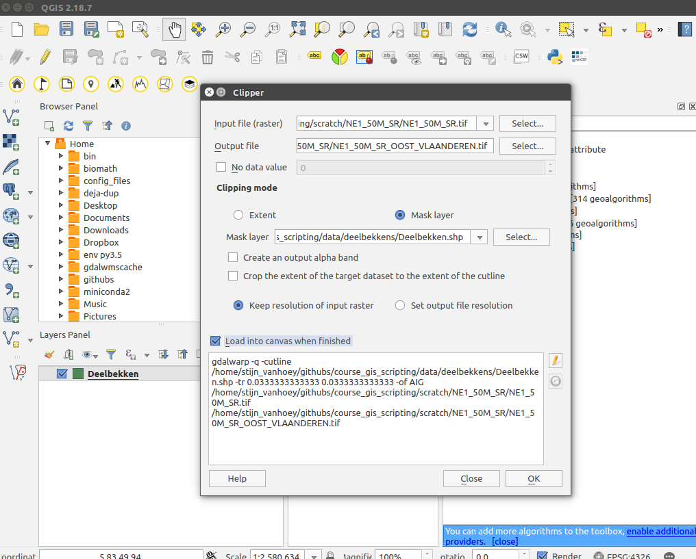 ] --- ## GDAL functions: Python * Import the GDAL library and use it within a script ```python from osgeo import gdal #... ``` -- * Write a Python function to call a specific GDAL command ```python # No 'from osgeo import gdal' (!) subprocess.call(['gdalwarp', inraster, outraster, '-cutline', inshape, '-crop_to_cutline', '-overwrite']) ``` --- class: center, middle # call GDAL `05-the-power-of-gdal.ipynb` --- ## Rasterio <br><br><br><br><br><br><br><br><br><br><br><br><br><br><br> <small>(*All credits to [Kelsey Jordahl](https://github.com/kjordahl/SciPy-Tutorial-2015) for the example*)</small> --- ### Rasterio python API ```python with rasterio.open('manhattan.tif') as f: img = f.read(1) imshow(img, cmap='gray') ``` .center[ 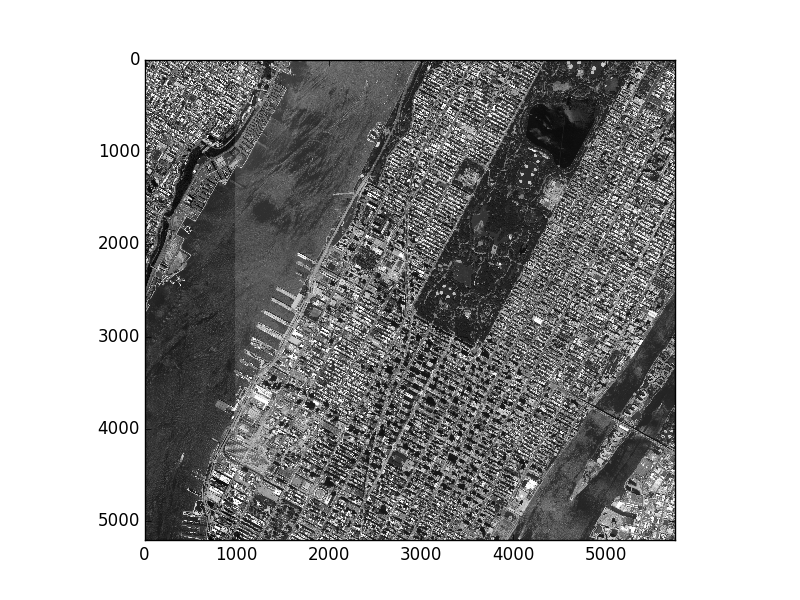 ] --- ### Rasterize vector features Using GeoPandas to generate a vector mask and applying it to a raster image with rasterio ([example](https://github.com/kjordahl/SciPy-Tutorial-2015/blob/master/examples/rasterio_mask.py)). .center[ 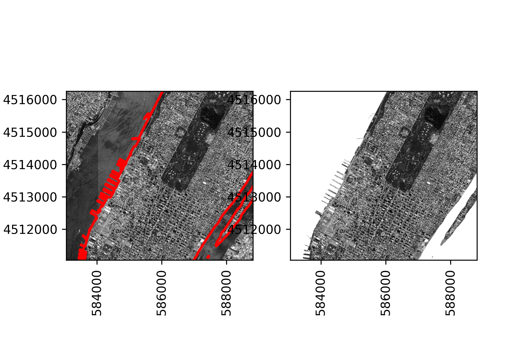 ] --- ### Rasterize vector features Using GeoPandas to generate a vector mask and applying it to a raster image with rasterio ([example](https://github.com/kjordahl/SciPy-Tutorial-2015/blob/master/examples/rasterio_mask.py)). ```python from rasterio.features import rasterize mask = rasterize([poly], transform=src.transform, out_shape=src.shape) ``` .center[ 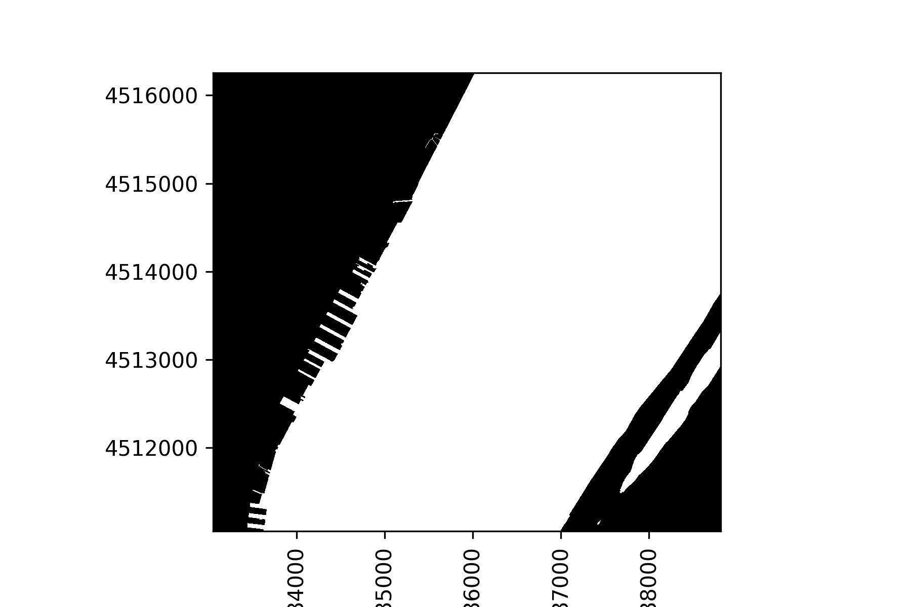 ] --- class: center, middle # Raster data in Python (*only for illustration purposes*) `06-gis-python-rasters.ipynb` --- count: false class: center, middle, bgheader background-image: url(./img/StijnVH-ecosystem-gis-6.png) background-size: cover --- count: false class: center, middle, bgheader background-image: url(./img/StijnVH-ecosystem-gis-7.png) background-size: cover --- count: false class: center, middle, bgheader background-image: url(./img/StijnVH-ecosystem-gis-8.png) background-size: cover --- count: false class: center, middle, bgheader background-image: url(./img/StijnVH-ecosystem-gis-9.png) background-size: cover --- count: false class: center, middle, bgheader background-image: url(./img/StijnVH-ecosystem-gis-10.png) background-size: cover --- count: false class: center, middle, bgheader background-image: url(./img/StijnVH-ecosystem-gis-11.png) background-size: cover --- # arcpy ```python import arcpy ``` The `arcpy` Package provides a [set of `objects` and `functions`](http://desktop.arcgis.com/en/arcmap/latest/analyze/arcpy-functions/alphabetical-list-of-arcpy-functions.htm) -- <br> For example, the interaction with Numpy: ```python arcpy.env.workspace = os.getcwd() + "\\demo.gdb" # connect to gdb arr = arcpy.da.TableToNumPyArray("canton", "pop_2008") print("Sum : {:,}".format(arr['pop_2008'].sum())) ``` -- <br> <div class="alert alert-info"> Hence, the same as we've been doing the whole day... (except of the licen$e) </div> -- You can also [export](http://desktop.arcgis.com/en/arcmap/10.3/analyze/modelbuilder/exporting-a-model-to-a-python-script.htm) a model builder setup<br> as a Python script and start working on it... --- class: center, middle # QGis scripts in Python `split vector layer by attribute`-demo --- class: center, middle  --- count: false class: center, middle  --- count: false class: center, middle  --- count: false class: center, middle  --- class: center, middle # QGis scripts in Python `split vector layer by attribute`-demo Check the information [here](https://docs.qgis.org/2.8/en/docs/user_manual/processing/scripts.html) and [here](http://docs.qgis.org/2.0/en/docs/user_manual/processing/console.html) to write your own QGIS scripts. --- class: center, middle, bgheader background-image: url(./img/StijnVH-ecosystem-gis-11.png) background-size: cover --- class: center, middle, bgheader background-image: url(./img/StijnVH-ecosystem-gis-11_alpha.png) background-size: cover <div class="alert alert-success"> Don't be overwhelmed,<br>enlarge your toolbox function by function... </div> --- class: center, middle ... and help each other!  --- class: center, middle ## Good luck! 